You are here:  Home » Sample Maps Home » Sample Maps
|
Samples
Streetwise Planning Maps
Ordnance Survey (OS) MasterMap
When only the most detailed site map will do
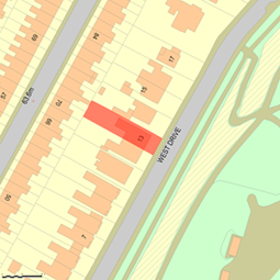
The OS Mastermap is the map of choice for block plans, site plans, and location plans at the largest scales.
Use this for standard scales of 1:1250, 1:2500 and 1:500. They can also be used for super scales of 1:200.
For scales at 1:10,000 or 1:50,000 use our Area maps below.
OS MasterMap is the intelligent digital map designed by Ordnance Survey for use in general business documents and with geographical information
systems (GIS). Based on the National Grid, it includes topographic information on every landscape feature - buildings, roads, phone boxes, postboxes,
landmarks - and represents a significant evolution from traditional cartography.
Streetwise Planning Maps contain four combined layers - each made up of various mapping features. Each feature has its own unique identifier or TOID.
This large scale mapping is therefore not only extremely detailed but also signiificantly more up-to-date than traditional maps.
Streetwise as an OS Platinum Partner is supplied with UK updates on a quarterly basis and so clients will always be able to view up-to-date mapping.
As the OS says "Ordnance Survey is committed to providing businesses with the most reliable datasets in Great Britain. Combined with your own
information, Ordnance Survey MasterMap® will always give the most detailed picture of your operational area."

36m x 36m @ 1:200
Scale
From £8.50 +VAT |
90m x 90m @ 1:500
Scale
From £8.50 +VAT |
2 hectare @ 1:1250
Scale
From £11 +VAT |
5 hectare @ 1:1250/1:2500
Scales From £21 +VAT |
16 hectare @ 1:2500
Scale
From £36 +VAT |
Select file format.

|
Select file format.
|
Select file format.

|
Select file format.
|
Select file format.
|
| |
|
|
|
|
130m x 130m @ 1:500 Scale A3
From
£11.00 +VAT |
55m x 55m @ 1:200 Scale A3
From
£8.50 +VAT |
Select file format.
|
Select file format.
|
Streetwise Area Maps
 Select file format

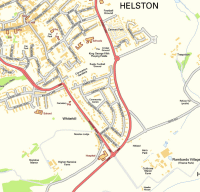
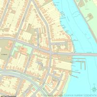
Streetwise 10k Maps from Ordnance Survey (OS) 1:10 000 Streetview
Ordnance Survey's OS Street View is street-level, backdrop map data that is specifically designed for online applications, as it can be downloaded
quickly from the Internet. It provides a scanned image of street-level mapping enabling you to clearly visualise a wide range of information in a
geographical context. The street-level detail of OS Street View makes it particularly useful for detailed location tasks and for analysing data about
specific localities as it includes building outlines, woodland and water.
OS Street View is fully compatible with the other Ordnance Survey digital data products.
 Select file format
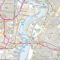
Streetwise 25k Maps from Ordnance Survey (OS) 1:25K Raster
1:25000 Scale Colour Raster mapping gives an excellent overview of the country. This small scale map combines key features such as
cities, towns and many villages, as well as features in the Ordnance Survey Road Map series, including all motorways and A and B
roads and railways.
OS Street View is fully compatible with the other Ordnance Survey digital data products.
 Select file format
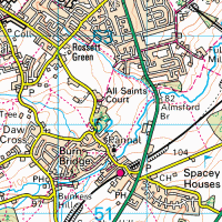
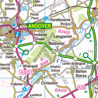
Streetwise 1:50k Maps from Ordnance Survey 1:50k raster
The Ordnance Survey 1:50k maps are great for showing the overview of a town or village.
1:50 000 scale colour raster map is Ordnance Survey's definitive raster product, providing a complete digital view of the popular Landranger paper map
series.
It comprises 812 tiles, each 20 km by 20 km, and offers clear detail on roads, footpaths, woods, water features, important buildings and height
contours.
Benefits
- Shows all roads and buildings as blocks of colour to allow easy identification of land features.
- Directly derived from Ordnance Survey Landranger production database, resulting in high quality image and resolution.
- Consistent with Landranger accuracy. All topographic features are edge-matched.
- Compatible with other Ordnance Survey data products.
 Select file format
Streetwise 1:250k Maps from Ordnance Survey 1:250k raster
1:250000 Scale Colour Raster mapping gives an excellent overview of the country. This small scale map combines key features such as
cities, towns and many villages, as well as features in the Ordnance Survey Road Map series, including all motorways and A and B
roads and railways.
 Select file format
Streetwise Larger Area Master Maps